
San Bernardino in Crisis: Navigating Flash Floods Amidst the Line Fire
As San Bernardino County confronts the escalating Line Fire, a new challenge has emerged in the form of severe weather. The National Weather Service (NWS) has issued a Flash Flood Warning for several areas within the county, compounding the threats facing residents and emergency responders. This dual crisis—fire and flooding—highlights the urgent need for vigilance, preparation, and resilience among the affected communities.
The Line Fire’s Relentless Advance
A Rapidly Expanding Wildfire
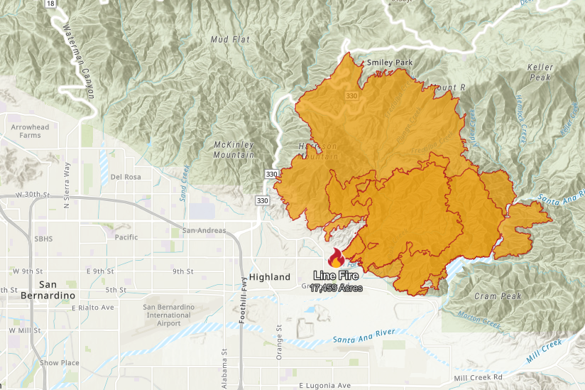
The Line Fire, which ignited late last week, has rapidly expanded, quadrupling in size as the weekend began. By Saturday alone, the fire scorched thousands of acres, racing up steep terrain and consuming thick vegetation. The blaze is now threatening Running Springs, a mountain community of about 5,000 people situated between the popular resort areas of Lake Arrowhead and Big Bear Lake. Evacuation orders are in place for Running Springs, and Lake Arrowhead and surrounding areas remain under an evacuation warning.
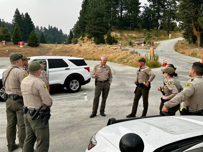
On the southern front, evacuation orders have been issued for parts of the city of Highland, where structures at the base of the mountains are at risk. The Line Fire’s erratic behavior has already resulted in injuries to three firefighters, highlighting the dangers faced by those battling the blaze. According to Cal Fire, the situation is expected to remain challenging due to a mix of hot, dry conditions and the threat of thunderstorms over the next few days.
Governor Gavin Newsom has proclaimed a state of emergency in San Bernardino County to secure federal assistance, as the fire threatens more than 35,000 homes and critical infrastructure. The blaze has “room to grow now in essentially three directions and there are population centers and pretty dense, dry vegetation in between those population centers,” noted Daniel Swain, a climate scientist at UCLA. The fire's intensity was underscored by the formation of a towering pyrocumulonimbus cloud—a fire-generated thunderstorm—producing its own lightning, erratic winds, and even brief periods of rain.
Support Our Team
Gain access to in-depth analysis and stay ahead with our monthly or yearly subscription, bringing you expert-driven articles tailored to keep you informed and empowered with the latest insights.
SupportCompounding Challenges: Flash Flood Warnings
Severe Weather Threatens to Aggravate Conditions
While firefighters grapple with the expanding wildfire, a Flash Flood Warning issued by the NWS adds another layer of complexity to the crisis. The warning, which remains in effect until 5:45 p.m. on Sunday, is due to thunderstorms that are expected to bring between 0.75 to 1.25 inches of rain per hour. Specific areas at risk include Wrightwood, Highway 2 between Phelan and Wrightwood, and Highway 138 between I-15 and Highway 2. As of the latest updates, between 1 to 1.5 inches of rain have already fallen, exacerbating the potential for flash floods.
These weather conditions not only threaten the safety of residents but also pose significant obstacles to firefighting efforts. Roads that are critical for evacuations and emergency access may become impassable, complicating the coordinated response to the Line Fire. Additionally, the risk of flash floods could lead to rapid water runoff in recently burned areas, increasing the likelihood of debris flows and mudslides.
Impact on Communities
The severe weather is also affecting Victorville, Hesperia, Adelanto, and Mountain View Acres, where the NWS has issued a severe thunderstorm warning. Residents in these areas are advised to avoid unnecessary travel and to stay informed of the latest weather updates. The dangers associated with driving through flooded roads cannot be overstated, as flash floods can quickly transform seemingly safe areas into hazardous zones.
For communities like Running Springs and Highland, which are already under evacuation orders or warnings, the added threat of flash floods could complicate evacuation procedures and heighten the sense of urgency. The NWS has strongly advised against traveling through flooded roads, emphasizing that safety should be the top priority for all residents in affected areas.
Preparing for the Worst: How to Stay Safe
Evacuation Preparations
As the Line Fire and flash floods present simultaneous threats, residents must be prepared to act swiftly. Cal OES recommends that those in evacuation zones pack essential items, including:
- Important documents (tax, banking, medical records)
- Prescription medications
- Identification (driver’s license, passport)
- Wallets and purses
- Cell phone chargers
- Family heirlooms
- Photographs or videos documenting the interior and exterior of homes
Having these items ready can make a significant difference in ensuring a safe and orderly evacuation. For those who have not yet been ordered to evacuate but are in areas with warnings, it’s crucial to stay alert and be prepared to leave at a moment’s notice.
Staying Informed
Staying informed through reliable sources is critical during this dual crisis. Residents should regularly check updates from the NWS, Cal OES, and other local emergency services to receive the latest information on weather conditions, fire status, and evacuation orders. Social media platforms, official websites, and local news outlets are valuable resources for real-time updates.
Unprecedented Challenges
San Bernardino County is facing an unprecedented challenge as it battles both a rapidly growing wildfire and severe weather conditions. The Line Fire’s relentless advance threatens tens of thousands of homes and critical infrastructure, while flash floods pose additional risks to communities and emergency response efforts. In these perilous times, the resilience and preparedness of residents will be crucial in navigating the overlapping crises.
As the situation evolves, all affected individuals need to remain vigilant, prioritize safety, and follow the guidance of emergency services. By preparing for the worst and staying informed, San Bernardino’s communities can better weather the storm and begin the long process of recovery once the immediate dangers have passed.